uganda's settlement: The beginning of uganda's recorded journey The settlement of Uganda is one of turmoil, war, and foreign occupation (BBC News, 2012). Because the earliest inhabitants who settle in Uganda only genealogically kept track of data, we know very little of early Ugandan history (Compassion, 2012). As a result, it is very hard to locate good, solid and accurate information on Uganda's early settlement. This is a summary of the details I could gather.
The earliest accounts begin at about 15th or 16th century, when non-European explorers began to frequent the area (Embassy of the People's Republic in China in the Republic of Uganda, 2004). However, it is widely agreed upon that before this, the land of Uganda was used by "Bushmen" (Compassion, 2012). After this time period, groups began to migrate and permanently settle in the land of Uganda. According to the Embassy of the People's Republic of China in the Republic of Uganda (2004), four main groups can be traced as having migrated to the country, each comprised of multiple tribes. The Bantus, traveling from the west, are the most well-known group. Being extremely large (much larger than the remaining three), they settled in the majority of Uganda-all areas but the east. The Ugandan territory within the circle on Figure 1 is the approximate region settled by the Bantus. The second group, named the Nilostias, came from the north. Two smaller groups, the NiloHamitias and the Sudanics were also included in the set (Embassy of the People's Republic in China in the Republic of Uganda, 2004). These groups soon formed kingdoms around the 16th century. These names also vary-according to the Embassy Embassy of the People's Republic in China in the Republic of Uganda (2004), the three kingdoms were called Buganda (the most powerful one), Kitara (comprised of Bunyoro & Toro), and Karagwe. However, according to another source, the kingdoms were called Buganda, Bunyoro, and Ankole (BBC News, 2012). They vied for power and at times, Buganda encroached on territories. At one time, it is said that held land from Lake Victoria to the Kagera River (BBC News, 2012). The approximate area of land held by Buganda can seen seen from the figure 2 on the right, hi-lighted with yellow/red. The foreign presence truly began when the first European came to Uganda in 1862. This eventually escalated into Uganda being colonized by the British in 1896 (Compassion International, 2012). This was final major step in the settlement of Uganda. Obviously, its colonization greatly affected the rest of its history. Uganda'settlement is one of ambiguity and interest; the country has a unique beginning. |
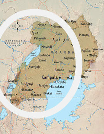
Fig. 1 The Ugandan region within the circle is the approximate region used by the Bantus. (Embassy of the Republic of China of the Republic of Uganda)
Map: (Compassion, 2000), annotated using pixlr.com
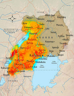
The yellow/red area is the approximate region that was held by Buganda at one time (BBC News, 2012)
Map: (Compassion, 2012), Annotated using pixlr.com
|
The physical Factor of uganda's settlement
|
A brief look at Uganda, encompassing settlement, history, population, and geography yields intriguing information and interesting results. Much of geography affected the population, settlement, and even the history of Uganda.
One site points out that the soil and climate of Uganda was a magnet for the people groups ("Uganda; history and," 2003). The climate will be looked at briefly.
1) Climate: a) Temperature-The graph to the left shows that the temperature-averaging in the 70's, is very moderate, with a high amount of rainfall (World Challenge Expeditions Limited). b) Precipitation Levels- As can be seen from the second map to the right, Uganda has an average of 2-3 mm a day. Of East Africa shown here, it would seem that Uganda has the most moderate precipitation levels-the east is drier, while to the west, we see higher levels of precipitation (Koninklijk Nederlands Meterorologisch Instituut, 2000). This seems to be one of the best climates to live in. It is also very useful for agricultural purposes-not too cold, not too hot, and good precipitation levels. Although these factors certainly affected Uganda's history, there are also many others that could be explored. However, this is one of the most important. With a good climate and soil, Uganda was worthy place for groups to settle. |
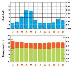
Figure 3. Ugandan Rainfall Levels and Temperature
(World Challenge Expeditions Limited, 2005)
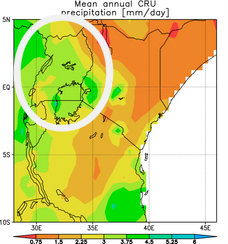
Figure 4. "Mean daily rainfall in East-Africa"
Map: (Koninklijk Nederlands Meteorologisch Instituut, 2000)
Annotated using pixlr.com
|
Uganda's population
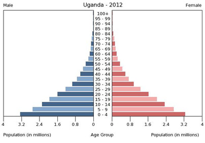
Figure 5. (Central Intelligence Agency, 2012)
(De Wulf)
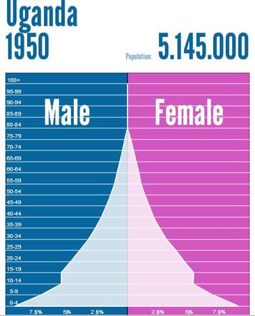
Figure 7. Uganda 1950 (De Wulf).
|
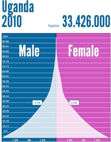
A study of Uganda's population is interesting and yet also sobering. As can be seen from Figure 5 and 6 on the left, the first of which can be found on the United States CIA's website and the second, on Population Pyramid, a majority of the Ugandan population is young, with over 3.2 million children between the ages of 0 and 4. However, there is only around 0.3 million between the ages of 50 and 54. This accounts for the fact that while there are 45.8 births/1,000 people while there are only 11.6 deaths/1,000 people (The World Factbook, 2012). Even though there are more births than deaths, the death rate is alarmingly high in the country according the The World Factbook (2012). The World Factbook (2012) also points out that the country is haunted by the presence of rampant diseases such as AIDS, malaria, typhoid, hepatitis A, and many, many others. This decreases the life span to 53 years, which also helps explain Figures 5 & 6; by the age of 53, there aren't many in the population still living. With such so many diseases, there is great need for medical help, but the country has relatively little in comparison with the population. As a result, the population isn't as large as it could be; many in Uganda are in a difficult state. The population of Uganda is growing, a younger population, and dramatically effected by diseases. (The World Factbook, 2012).
Although Uganda population is young today, with a small percentage of people living after fifty years according to figure 6, has it always been this way? By looking at figure 7, retrieved from Population Pyramid, the answer is generally "yes." However, in 1950, the numerical difference between the young and old in Uganda was not nearly as stark. It seems that figure 7 shows a pattern of birth/death rates in Uganda. In this figure, when those between the ages of 15 and 50 were born, it seems that the birth rate in conjunction with the death rate was fairly steady, but not incredible. However, in the age group around 5-14, the population drops significantly. This could either point to a low birth rate, a high death rate, or a tragedy during this time. After this, the birth rate seems have started increasing again. So, I believe that the difference can partially be explained by the birth rate of a particular era. However, the reasons for these fluctuations in birth and death rates are much harder to unearth. Even so, we can make some speculations. For example, hardly anyone survived in Uganda beyond 80 years old in 1950; however, in 2010, a small portion of the population is surviving at this age. This could be because of improved medical care. Conversely, it seems that there were more of the population over fifty living in 1950 than 2010-one factor could be the many diseases that continue to hit Uganda, especially HIV which is a fairly recent disease. The changes between the two figures speak of an ever-increasing birth rate in present Uganda, and improvements and drawbacks in the survival of the elderly.
|
Want more information? look into these sites for additional resources:
The Library of Congress's Country Study of Uganda: http://memory.loc.gov/frd/cs/ugtoc.html#ug0013
The Embassy of China's Summary of Uganda's History: http://ug.china-embassy.org/eng/wgdjj/t168250.htm
Compassion International's Qucik Summary of Uganda's History: www.compassioninternational.com/about/where/uganda
History on the Settlement of Africa in General: http://web.mesacc.edu/dept/d10/asb/africa/africa.html
sources
British Broadcasting Corporation. (2012, Nov 25). Bbc news. Retrieved from http://www.bbc.co.uk/news/world-africa-14112446
Central Intelligence Agency. (Designer). (2012). Uganda population pyramid. [Web
Graphic]. Retrieved from https://www.cia.gov/library/publications/the-world-factbook/population/populationtemplate_UG.html
Compassion International. (2012). Uganda [Web log message]. Retrieved from http://www.compassion.com/about/where/uganda.htm
Compassion International. (Designer). (2000). Uganda map. [Web Map]. Retrieved from
http://www.compassion.com/about/where/uganda.htm
De Wulf, Martin. Uganda 1950. 2008. n.p. Web. 21 Feb 2013.
<http://populationpyramid.net/Uganda/1950/>.
De Wulf, Martin. Uganda 2010. 2008. n.p. Web. 21 Feb 2013. <http://populationpyramid.net/Uganda/2010/>.
Embassy of the People's Republic of China in the Republic of Uganda. (2004, October 28). [Web log message]. Retrieved from http://ug.china-embassy.org/eng/wgdjj/t168250.htm
Koninklijk Nederlands Meteorologisch Instituut. (Designer). (2000). Mean daily rainfall in east-africa. [Web Map]. Retrieved from http://www.catsg.org/cheetah/07_map-centre/7_3_Eastern-Africa/thematic-maps/thematic-maps.htm
The World Factbook. In (2012). CIA. Retrieved from https://www.cia.gov/library/publications/the-world-factbook/geos/ug.html
Uganda; history and politics. (2003, January). Retrieved from http://www.iss.co.za/Af/profiles/Uganda/Politics.html
World Challenge Expeditions Limited. (Designer). (2005). Retrieved from http://www.worldchallenge.co.uk/expeditions/uganda_destination_information.asp
